Land Clearing Near Me in Central Ohio means crews who understand Brookston-Crosby clays, glacial till, and local NPDES rules from Columbus to Newark. Fortress Level Construction, based in Westerville since 2009, clears lots and acreage with Ohio-ready equipment. Call (844) 656-0129 to schedule a site walk built around Central Ohio conditions.
Quick Facts — Land Clearing Near Me
Why ‘Land Clearing Near Me’ Matters in Central Ohio
Choosing Land Clearing Near Me in Central Ohio means working with a Westerville-based team that knows the region’s soils and regulations block by block, from Columbus neighborhoods sitting on Brookston-Crosby clay to Liberty Township tracts over karst limestone. Fortress Level Construction plans equipment and erosion controls around Ohio’s spring thaw, when clay-saturated sites along the Scioto and Olentangy watersheds rut easily and need low-ground-pressure track machines. See county-specific details: Franklin (/land-clearing-franklin-county-ohio/), Delaware (/land-clearing-delaware-county-ohio/), Licking (/land-clearing-licking-county-ohio/), Fairfield (/land-clearing-fairfield-county-ohio/), Union (/land-clearing-union-county-ohio/).
Local knowledge matters because Central Ohio’s project mix ranges from tight urban lots in the Columbus Arena District and Bexley’s tree-lined streets—where historic overlays and tree ordinances guide removals—to rural parcels in Licking County near the Intel chip plant construction zone, where haul routes on OH-161 face heavy traffic. In Fairfield County near the Hocking River floodplain, clearing schedules must account for floodplain restrictions and Ohio EPA stormwater controls; while in Union County’s prime glacial-till farmland outside Marysville, clearing on agricultural easements requires coordination with the county engineer and Soil & Water Conservation District.
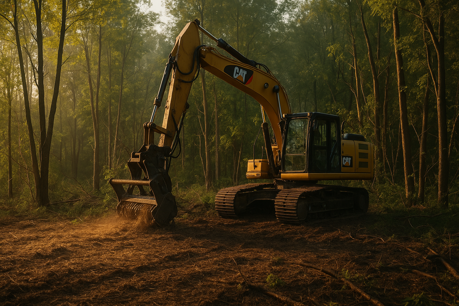
What Land Clearing Near Me Services Include
- Forestry mulching tailored to Ohio vegetation: High-flow mulchers knock back multiflora rose, honeysuckle, and autumn olive along Olentangy and Alum Creek corridors, producing on-site mulch ideal for Central Ohio clay moisture control. Learn more: /forestry-mulching-central-ohio/.
- Full clearing and grubbing for Ohio builds: From Powell infill lots under HOA guidelines to Lancaster hillside pads in the shale-sandstone transition, crews fell, stump, and root rake to the frost line typical of Central Ohio (about 32 inches). Related: /site-prep-central-ohio/.
- Brush and tree removal under city codes: In Columbus, Upper Arlington, and Worthington, removals follow municipal tree ordinances and right-of-way permits, coordinating with AEP Ohio, Columbia Gas of Ohio, and Del-Co Water locates via 811. See: Tree Clearing Central Ohio.
- Stump grinding designed for glacial till: Grinding depth is adjusted for Brookston-Crosby clays in Franklin County to prevent heave, and for karst-sensitive zones in Powell and Liberty Township to avoid voids. Details: /stump-grinding-central-ohio/.
- Access road and clearing for Intel-era logistics: In Johnstown and New Albany near the OH-161 corridor, temporary construction entrances meet Ohio EPA Construction General Permit (CGP) tracking pad specs with ODOT #2 stone. Explore: Construction Entrances Central Ohio.
- Drainage and erosion controls per Ohio EPA: Silt fence on Hocking River floodplain edges in Fairfield County, inlet protection in Gahanna curb-and-gutter streets, and stabilized outfalls for Newark lots tie into the local storm sewer MS4 rules. See: /drainage-central-ohio/.
- Pasture and fence line reclamation in Union County: Clearing shelterbelts and hedgerows around Marysville and Richwood respects agricultural preservation easements and field tile patterns common in deep glacial till. Overview: Pasture Clearing Central Ohio.
- Habitat and trail cuts around Buckeye Lake: Selective clearing in Hebron and Buckeye Lake balances access with ODNR guidance for riparian buffers along small tributaries feeding the Licking River. Learn more: Selective Clearing Central Ohio.
How Close Is the Nearest Fortress Level Crew?
Operating from Westerville, Fortress Level Construction reaches county seats fast on I-270, US-23, OH-161, and US-33—crucial in Central Ohio where commute windows vary. Typical drive times: Columbus (Franklin County seat) 15–25 minutes via I-270; Delaware (Delaware County seat) 20–35 minutes via US-23; Newark (Licking County seat) 30–45 minutes via OH-161; Lancaster (Fairfield County seat) 35–50 minutes via US-33; Marysville (Union County seat) 25–40 minutes via OH-257 or US-33. Those windows flex around OSU game days near Ohio Stadium, rush-hour bottlenecks on I-71/I-270, and construction near the Intel site in Licking County, allowing planning that keeps your Central Ohio site on schedule.
What Does Land Clearing Near Me Cost in Central Ohio?
In Central Ohio, land clearing costs reflect local variables like Brookston-Crosby clay saturation in Franklin County, karst risk in Powell/Liberty Township, traffic surcharges on the OH-161 corridor near New Albany and Johnstown, and floodplain mitigation near the Hocking River in Fairfield County. Light brush mulching on flat glacial till around Marysville often ranges $1,800–$3,200 per acre, while mature hardwood clearing with stump removal in Gahanna or Worthington infill lots can range $5,000–$12,000 per half-acre because of tight access and Columbus right-of-way permits. Along Newark’s sandstone ridges or Lancaster’s steeper ground, slope and rock content can add dozer-and-excavator time, pushing full clearing with haul-off to $6,000–$15,000 per acre. Urban projects in Columbus neighborhoods like German Village or Grandview Heights typically involve confined staging areas, overhead utilities, and historic district consultations—factors that may add $1,000–$3,000 in protection measures and handwork. Rural Licking County tracts (30–180 acres) often benefit from scale and easier access, but require longer mobilizations and more erosion controls if crossing streams tied to the Licking River watershed, adding $600–$1,500 per acre depending on BMPs.
| Central Ohio Scenario | Typical Cost Range | Local Factors | Counties/Cities |
|---|---|---|---|
| Light brush mulching, flat field edge | $1,800–$3,200/acre | Glacial till, minimal stumps, winter freeze window | Union (Marysville, Plain City), Delaware (Sunbury) |
| Moderate clearing w/ stump grinding | $3,500–$7,500/acre | Brookston-Crosby clays, spring saturation | Franklin (Gahanna, Hilliard, Grove City) |
| Heavy timber clearing w/ haul-off | $6,000–$15,000/acre | Urban access, permits, hardwood volume | Columbus, Upper Arlington, Bexley |
| Karst-sensitive clearing (Powell/Liberty Twp) | $4,500–$10,000/acre | Sinkhole risk studies, staged grubbing | Delaware County (Powell, Liberty Twp) |
| Floodplain-adjacent clearing | $4,000–$9,000/acre | Hocking River BMPs, matting, dewatering | Fairfield (Lancaster, Amanda) |
| Large rural acreage (30–180 acres) | $2,200–$5,800/acre | Scale efficiencies, multiple mobilizations | Licking (Newark, Johnstown), Union (Richwood) |
| Small city lot, tight access | $3,000–$12,000/lot | Hand-felling, protection mats, permits | Columbus (Clintonville, Grandview Heights) |
Line items often seen in Central Ohio bids include Ohio EPA CGP-compliant inlet protection ($150–$300 each around Columbus MS4 intakes), ODOT #2 stone tracking pads ($1,200–$2,400 per entrance near Newark and New Albany sites), and grinding/hauling surcharges in restricted open-burning jurisdictions like Columbus. Call (844) 656-0129 for a Westerville-based site review that ties costs to your exact county and soil profile.
Ohio Regulations for Land Clearing Near Me
Central Ohio land clearing intersects federal, state, and county rules. Projects 1 acre or larger typically need coverage under the Ohio EPA Construction General Permit (CGP) for stormwater and a local NPDES notice to the municipal MS4—crucial in Columbus, Dublin, and Hilliard. Work near streams or wetlands tied to the Scioto, Olentangy, or Licking River systems may involve the U.S. Army Corps (Section 404/401) and Ohio EPA Isolated Wetlands permits. Utility locates via Ohio 811 are mandatory across Franklin, Delaware, Licking, Fairfield, and Union Counties.
Franklin County and Columbus: The City of Columbus Stormwater Manual governs erosion and sediment controls in neighborhoods from Westerville’s southern edge to Grove City. Tree and right-of-way permits vary by municipality: Gahanna, Upper Arlington, Bexley, Worthington, Reynoldsburg, Whitehall, Groveport, Dublin, New Albany, Grandview Heights, and Columbus each maintain review steps that can affect clearing schedules. Open burning of land-clearing waste is restricted under OAC 3745-19; many Franklin County jurisdictions require chipping or hauling rather than burns.
Delaware County: Rapid growth in Powell, Lewis Center, and Sunbury means more HOA covenants and site-plan reviews through the Delaware County Regional Planning Commission. Liberty Township’s karst-prone limestone calls for sinkhole avoidance and engineered BMPs. The Delaware County Soil & Water Conservation District reviews SWPPP measures, especially along the Olentangy River corridor.
Licking County: Newark, Heath, Pataskala, Granville, Johnstown, Hebron, and Buckeye Lake projects may face haul-route timing constraints along OH-161 due to Intel construction traffic. The Licking County Planning Commission and the Soil & Water Conservation District coordinate on sediment controls, while Buckeye Lake-area work considers ODNR-managed water levels and shoreline protections.
Fairfield County: In Lancaster, Pickerington, Canal Winchester, Baltimore, and Amanda, floodplain development near the Hocking River requires permits through the county floodplain administrator and adherence to the Fairfield County Erosion & Sediment Control Handbook. Clearing within mapped flood zones may require matting and seasonal windows to reduce rutting on shale-sandstone transition soils.
Union County: Marysville, Plain City, and Richwood jobs often overlap agricultural preservation easements and CAUV considerations. The Union County Engineer may review entrances on county roads, while the Soil & Water Conservation District emphasizes protecting field tiles in deep glacial till. Many rural areas allow chipping or controlled burns with prior authorization under OAC 3745-19; verify with local fire departments.
Our Land Clearing Near Me Process — What to Expect
On-Site Walk in Westerville-Centered Radius
A project lead meets you on site—from a Worthington infill lot on Brookston clay to a Newark ridge near sandstone outcrops—to review access via I-270/OH-161, identify protected trees under Columbus or Granville codes, and note nearby waterways like Alum Creek or the Hocking River that trigger Ohio EPA BMPs.
Underground and Environmental Due Diligence
Ohio 811 locates are requested for AEP Ohio, Columbia Gas of Ohio, and Del-Co Water. If you’re in Powell/Liberty Township, the crew screens for karst features; in Fairfield County floodplains, we plan mats and silt fence. Wet spots along Scioto or Licking tributaries lead to Corps and Ohio EPA reviews as needed.
Ohio-Ready Clearing Plan and SWPPP
A plan calibrated to Central Ohio climate and soils sets erosion controls (silt fence, inlet protection in Gahanna curb inlets), ingress/egress on ODOT #2 stone, and sequencing around the region’s frost depth (~32 inches). Urban lots in Bexley or Upper Arlington include tree protection zones and narrow-street staging.
Equipment Mobilization for Glacial Till and Clay
Low-ground-pressure track loaders and excavators with thumbs arrive from Westerville. For Brookston-Crosby clays common in Franklin County, the crew uses mats to limit rutting during March–April thaws. On Union County farmlands, attention to field tiles and drain outlets prevents downstream issues.
Clearing, Grubbing, and Material Management
Trees are felled with skyline awareness under Columbus and Dublin overhead utilities. Stumps are extracted or ground considering clay heave in Central Ohio. Chips are reused as mulch in Delaware County HOA buffers when allowed, or hauled to local facilities if open burning is restricted by OAC 3745-19.
Final Grading and Ohio EPA Closeout
Finish grading aligns with Ohio’s SWPPP stabilization timelines—seeding with KY-31 or native mixes specified by county Soil & Water. In Newark or Lancaster, inlet protection remains until streets are broom-clean. A final walkthrough confirms compliance for municipal inspectors in Columbus-area MS4 jurisdictions.
Why Central Ohio Property Owners Choose Fortress Level
From a Westerville base, Fortress Level Construction has worked Central Ohio soils and seasons since 2009—long enough to know spring saturation on Franklin County clays, the sinkhole mapping that matters in Powell, and when to time Union County farm clearings around harvest and freeze. Track machines with low ground pressure, forestry mulchers tuned for Ohio invasives, and mats for Hocking River floodplain approaches keep sites stable in Lancaster and Amanda. Crews schedule around OSU game-day traffic and OH-161 congestion near New Albany and Johnstown, so deliveries don’t stall your Columbus or Licking County project.
Owner involvement ensures your plan reflects real Central Ohio constraints: frost-line depth around 32 inches for stump work, NPDES permitting in MS4 areas from Dublin to Grove City, and city-specific tree protections in Bexley, Upper Arlington, and Gahanna. The team coordinates with Franklin, Delaware, Licking, Fairfield, and Union County Soil & Water offices and plans haul routes that avoid weight-limited rural bridges near Buckeye Lake or Richwood.
Is Fortress Level the Right Fit?
If you’re clearing 30–180 acres in Licking County near the Intel corridor between Johnstown and Alexandria, Fortress Level Construction brings the mulching capacity and dozer/excavator mix to handle both timber and sandstone knobs while navigating OH-161 traffic restrictions. Farmers in Union County around Marysville, Plain City, and Richwood benefit from field-edge and hedgerow clearing that respects field tiles and CAUV agricultural status, with winter windows that minimize rutting in deep glacial till.
Builders and realtors prepping infill in Franklin and Delaware Counties—Columbus, Westerville, Dublin, Powell, Hilliard, Gahanna, and Worthington—get tight-access solutions that respect Brookston-Crosby clays and city codes, from staging on narrow Bexley streets to tree protection fencing in Upper Arlington. Hunters and habitat managers near Buckeye Lake, Hebron, and Granville can expect selective clearing and trail cutting that maintain riparian buffers per ODNR guidance. Homeowners in Pickerington, Canal Winchester, Reynoldsburg, Whitehall, and Groveport can pair brush removal with drainage improvements to match Ohio EPA stabilization timelines.
What Central Ohio Clients Say
“Fortress Level cleared 42 acres outside Johnstown in Licking County for access roads to a future warehouse near the Intel build. They timed mulching around OH-161 lane closures and used ODOT #2 stone at the entrance for Ohio EPA CGP compliance. Newark inspectors signed off with no corrections.” — Mark R., Johnstown, OH
“On our Bexley lot in Franklin County, the crew protected street trees per city ordinance, chipped everything because Columbus restricts open burning, and ground stumps deep enough to handle Central Ohio’s freeze-thaw. From Westerville to Bexley, the 20-minute mobilization kept us on schedule.” — Carla S., Bexley, OH
“Our Marysville farm had field tiles everywhere. Fortress Level mapped outlets, avoided damage during edge clearing, and reclaimed 1,200 feet of fence line in Union County glacial till. Winter timing reduced ruts, and the Soil & Water inspection went smoothly.” — Dave L., Marysville, OH
Areas We Serve
Franklin County
Pop: 1,323,807 | 10-25 min from Westerville
Delaware County
Pop: 214,124 | 15-35 min from Westerville
Licking County
Pop: 180,564 | 25-45 min from Westerville
Fairfield County
Pop: 161,551 | 30-50 min from Westerville
Union County
Pop: 61,578 | 25-40 min from Westerville
Frequently Asked Questions About Land Clearing Near Me
Related Articles — Land Clearing Near Me in Central Ohio
Get Your Free Land Clearing Near Me Estimate Today
Fortress Level Construction handles residential lots, commercial parcels, farm acreage, and everything in between across Central Ohio’s 5-county service area.
Fast Turnaround | Local Westerville Crew | Written Estimates, No Surprises