Grading Company Central Ohio services from Fortress Level Construction keep Columbus-area pads stable and lots dry across Franklin, Delaware, Licking, Fairfield, and Union Counties. From Westerville’s Brookston clay to Powell’s karst, crews tailor grades to Ohio soils. Call (844) 656-0129 for an on-site review within Ohio EPA and county rules.
Quick Facts — Grading Company
Why ‘Grading Company’ Matters in Central Ohio
In Central Ohio, a grading company’s decisions must be shaped by the soils and frost cycles that define Franklin, Delaware, Licking, Fairfield, and Union Counties. Westerville and Columbus neighborhoods sit on Brookston-Crosby clay over glacial till, so spring thaw around I-270 and the Scioto Mile area can swell subgrades and heave concrete if slopes and compaction aren’t tuned for Ohio’s 32–36 inch frost line. Even a small backyard in Gahanna or a tight lot in Grandview Heights needs grades set to push runoff toward storm inlets required by the City of Columbus, not toward basements on clay that drains slowly.
Drive 15–35 minutes north from Westerville into Delaware County and you hit a different problem—karst limestone pockets through Powell and Liberty Township that can divert water underground and create settlement risk. In Lewis Center and Sunbury, a grading plan often includes undercutting weak spots and adding geotextile over stone to bridge void-prone areas per typical ODOT 203/204 practices common in Central Ohio public works. In Licking County, 25–45 minutes east toward Newark, Dawes Arboretum, and the Intel site off SR-161, heavy lowland clay transitions to sandstone ridges near Granville, asking for different slopes and ditching than the Hocking River–influenced floodplains to the south in Fairfield County near Lancaster and Canal Winchester.
Union County, 25–40 minutes northwest to Marysville across deep glacial till and prime farmland soils, calls for careful topsoil stripping and replacement to preserve crop yields, especially along US-33 near Honda of America manufacturing. Across these counties—each with distinct rules and review boards—a local grading company like Fortress Level Construction aligns slopes with county stormwater criteria and Ohio EPA standards. Explore county-specific grading details here: Franklin County: /grading-company-franklin-county-ohio/ | Delaware County: /grading-company-delaware-county-ohio/ | Licking County: /grading-company-licking-county-ohio/ | Fairfield County: /grading-company-fairfield-county-ohio/ | Union County: /grading-company-union-county-ohio/.
What Grading Company Services Include
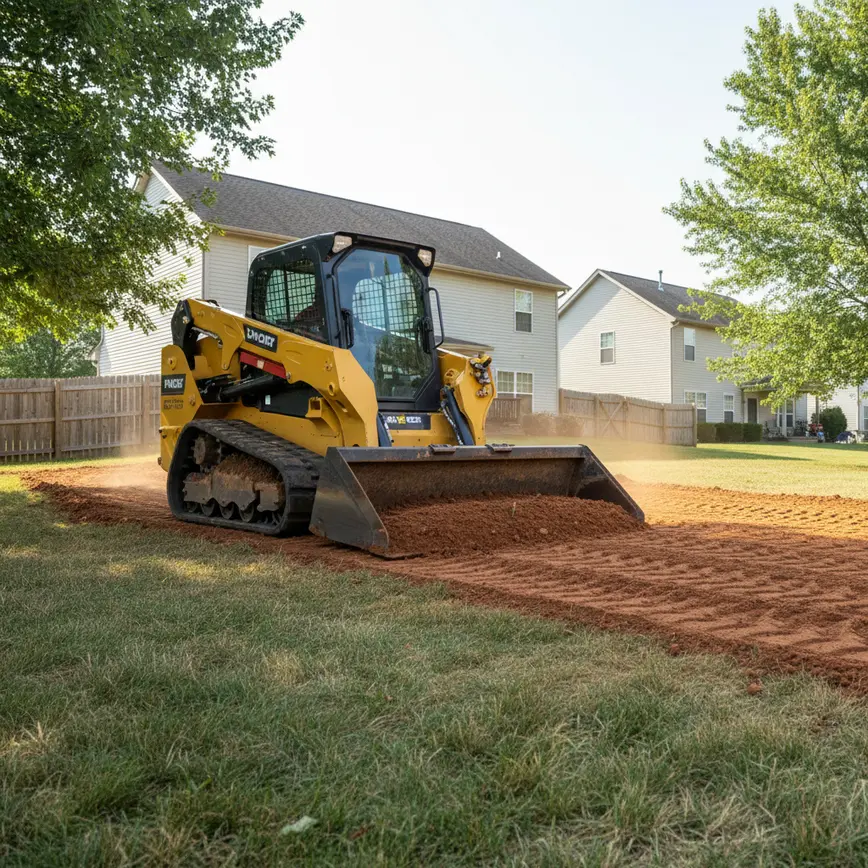
- Residential lot grading for Franklin County cities like Columbus, Dublin, and Upper Arlington, dialing slopes to 1–2% per OSU Extension drainage guidance and tuning compaction for Brookston-Crosby clays so patios don’t heave after Central Ohio freeze-thaw. Related: /driveway-grading-central-ohio/.
- Building pad construction in Licking County (Newark, Johnstown, Pataskala) with undercutting and engineered fill to meet 95–98% Proctor density often requested by city inspectors near the Intel corridor off SR-161. Related: /excavation-central-ohio/.
- Farm lane and barn pad grading across Union County (Marysville, Plain City, Richwood) over deep glacial till, balancing cuts and fills to preserve prime soils documented by the county’s agricultural easements. Related: /land-clearing-central-ohio/.
- Karst-aware grading in Delaware County (Powell, Liberty Township) where limestone voids require proof-rolling and geogrid, preventing sinkhole risk that has affected parts of Olentangy school developments. Related: /drainage-contractors-central-ohio/.
- Hillside reshaping and terrace cuts in Fairfield County near Lancaster and Amanda, stabilizing shale and sandstone transition slopes and directing runoff away from the Hocking River floodplain overlays. Related: Erosion Control Central Ohio.
- Urban infill grading in Franklin County neighborhoods like Bexley, Worthington, and Clintonville (Columbus), navigating tight alley access and historic overlays in areas like German Village that require review before changing grades. Related: Site Prep Central Ohio.
- Drainage swales, culverts, and French drains from Gahanna to Grove City tied into municipal storm systems following City of Columbus and Franklin County Engineer inlet specs to protect downstream Scioto watershed quality. Related: /drainage-contractors-central-ohio/.
- Driveway regrades and stone resurfacing in Licking County lake communities around Buckeye Lake and Hebron, compacted to withstand high truck traffic from ongoing construction near SR-79. Related: /driveway-grading-central-ohio/.
- Commercial parking lot subgrade shaping in Whitehall and Reynoldsburg to meet ODOT 204 subgrade tolerance, crucial on clayey tills that pump under traffic during wet Ohio springs. Related: Commercial Excavation Central Ohio.
- Pond site grading and overflow swales near Galena, Sunbury, and Granville, with emergency spillways set to Ohio NRCS recommendations to handle intense summer storms common across Central Ohio. Related: /pond-excavation-central-ohio/.
How Close Is the Nearest Fortress Level Crew?
Operating from Westerville since 2009, Fortress Level Construction dispatches across a five-county radius on I-270, SR-161, US-33, and US-23 corridors. Typical drive times from Westerville to county seats are 10–25 minutes to Columbus (Franklin County), 20–30 minutes to Delaware (Delaware County), 30–40 minutes to Newark (Licking County), 35–50 minutes to Lancaster (Fairfield County), and 30–40 minutes to Marysville (Union County), keeping mobilization fast for grading in cities like Dublin, Hilliard, Grove City, New Albany, Powell, Granville, Pickerington, and Plain City under Ohio’s variable weather windows.
What Does Grading Company Cost in Central Ohio?
In Central Ohio, grading costs reflect Ohio soils, haul distances, and permit complexity. A small residential regrade in Franklin County (Columbus, Gahanna, Worthington) often runs $2,500–$9,500 depending on Brookston-Crosby clay moisture and access through alleyways or narrow lots typical near OSU and the Arena District. Rural acre grading in Union or Licking County commonly ranges $4,000–$15,000 per acre, with rates influenced by topsoil depth in glacial till near Marysville and the stiffer clays around Newark and Granville. Costs rise when Ohio EPA Construction General Permit (OHC000006) thresholds are met (disturbance of 1+ acre), as SWPPP/SWP3 development, erosion controls like ODOT spec filter sock, and stabilized construction entrances become mandatory. Importing fill from local quarries (Shelly, National Lime & Stone) around Delaware, Sunbury, or Groveport can add $18–$42 per cubic yard delivered depending on fuel, source pit, and whether the site lies west of I-71 or east along SR-161 near Intel traffic. Floodplain overlays along the Hocking River near Lancaster, or karst risk in Powell, may require undercut and geogrid ($6–$14 per square yard) to stabilize subgrades. Residential builders in New Albany or Dublin often budget to Ohio’s frost depth of 32–36 inches, using pad crowns and 2% minimum surface slopes recommended by OSU Extension so winter freeze-thaw around Columbus doesn’t push water under slabs. When building near Buckeye Lake in Licking County or on shale slopes south of Canal Winchester in Fairfield County, prices shift to include terrace cuts, riprap, and tighter erosion controls per county engineer and EPA notes.
| Project Type (Central Ohio) | Typical Range | Soil/Condition Impact (Ohio) | County Notes |
|---|---|---|---|
| Urban residential lot (Columbus, Bexley, Grandview) | $2,500–$9,500 | Brookston-Crosby clay holds water; compaction timing around spring rains critical | Franklin County: tight access; historic overlays in German Village add review time |
| 1–5 acre rural home site (Sunbury, Johnstown, Plain City) | $6,000–$22,000 | Topsoil strip/respread over glacial till; driveway ditches needed for OSU-recommended drainage | Delaware/Licking/Union: HOA in Powell or Liberty Twp can add requirements |
| 10–50 acre farm lane & barn pad (Marysville, Richwood) | $18,000–$120,000 | Prime farmland soils demand careful cut/fill; stone underdrain where seeps occur | Union County: ag easements guide disturbance limits along US-33 corridor |
| Hillside grading (Lancaster, Amanda) | $12,000–$48,000 | Shale/sandstone transition slopes; terrace benches and riprap for Hocking watershed | Fairfield County: floodplain checks near Hocking River add review |
| Commercial pad near SR-161 (New Albany, Hebron) | $35,000–$250,000+ | Stiff clay subgrades; undercut, geogrid, and 98% Proctor compaction typical | Licking County: Intel-area traffic affects trucking times and costs |
Every estimate from Fortress Level Construction is built around the specific Ohio county review path—whether that’s a quick call with a Franklin County inspector off Morse Road or a full SWP3 package for Delaware County stormwater, plus Ohio811 utility locates to confirm depths along Westerville’s older neighborhoods.
Ohio Regulations for Grading Company
Central Ohio grading must follow the Ohio EPA NPDES Construction General Permit (OHC000006) when disturbing one acre or more, requiring a SWPPP/SWP3, perimeter BMPs like silt fence or filter sock per ODOT Item 207, and stabilized construction entrances that are standard on Columbus projects within the Scioto and Olentangy watersheds. For sub-acre work, Columbus Building & Zoning still expects runoff to flow to approved outlets, and many city inspectors in Franklin County reference ODOT 203/204 for subgrade tolerance and compaction methodology.
Delaware County’s rapid growth around Powell, Lewis Center, and Sunbury leads to frequent plan reviews through the County Engineer for stormwater, and HOAs near the Olentangy Local Schools often require architectural approvals before altering grades. In Powell and Liberty Township, karst mapping is a practical necessity; grading submittals sometimes request geotechnical notes to address sinkhole potential linked to the county’s limestone geology along US-23 and SR-315 corridors.
Licking County jurisdictions—Newark, Johnstown, Pataskala, Granville, and Hebron—coordinate erosion control closely, especially around Intel’s $20B site off SR-161, where trucking restrictions and haul routes are scrutinized. Wetlands are regulated under USACE Section 404 with Ohio EPA 401 Water Quality Certification; isolated wetlands fall under Ohio Revised Code 6111. Fairfield County floodplain overlays near the Hocking River require permits before regrading, particularly around Lancaster and Amanda where shale slopes meet valley floors. Union County projects north of Marysville near Honda’s US-33 plants often span 50–180 acres, and agricultural preservation easements can limit cut/fill extents; grading plans there typically go through the Union County Engineer to protect prime soils.
Our Grading Company Process — What to Expect
On-site walk in Westerville or your county seat
A local foreman meets you in Central Ohio—whether that’s a Clintonville alley in Columbus or a farm lane in Marysville—to evaluate Brookston clay, glacial till, or karst indicators. Measurements align with Ohio’s 32–36 inch frost line and city drainage points so runoff flows to approved inlets and ditches.
Utility locates and county coordination
Ohio811 locates are ordered around Columbus, Dublin, or Newark, confirming lines near SR-161 and I-270 corridors. If disturbance approaches one acre, Fortress Level prepares SWP3 per Ohio EPA CGP OHC000006, coordinating with county engineers in Franklin, Delaware, Licking, Fairfield, or Union for stormwater notes.
Erosion controls to Ohio standards
Perimeter BMPs like filter sock and silt fence are installed to ODOT Item 207 norms used regionally across Central Ohio, with stabilized entrances common on projects near Grove City clay or Hebron job traffic. Controls are placed to protect the Scioto, Olentangy, and Hocking River watersheds.
Rough grading for Ohio soils
Cut/fill balances consider Delaware County karst by proof-rolling and bridging void-prone zones, while Fairfield County’s shale slopes get stepped benches. In Union County till, topsoil is stripped, stockpiled, and later respread to maintain soil health under OSU Extension guidance for Central Ohio fields.
Compaction to local specs
Pads are densified to 95–98% Proctor, meeting typical Central Ohio inspector expectations referencing ODOT 203/204. On Franklin County clays, sheepsfoot and smooth-drum rollers are sequenced during dry weather windows; Dublin, Worthington, and Bexley lots receive 1–2% surface falls away from foundations.
Final grade, punch, and sign-offs
Seed and straw or hydroseed are applied per county and City of Columbus stabilization timeframes. Fortress Level walks the site with you in Westerville, Newark, or Lancaster, confirms drainage to inlets, submits any required as-builts, and removes BMPs once Ohio EPA rules allow.
Why Central Ohio Property Owners Choose Fortress Level
From Westerville, Fortress Level Construction reaches Franklin County job sites in 10–25 minutes, tackling Brookston-Crosby clays that saturate after spring rains along the Scioto Mile and Arena District. The team’s low-ground-pressure track machines and sheepsfoot rollers are selected for Ohio’s glacial tills and clay loams, minimizing rutting during March–April thaw that often plagues Gahanna, Hilliard, and Grove City projects.
In Delaware County—Powell, Lewis Center, Galena, and Sunbury—experience with karst and HOA overlays reduces review cycles near Olentangy schools. To the east in Licking County (Newark, Johnstown, Granville, Pataskala, Hebron, Buckeye Lake), schedules account for SR-161 congestion tied to Intel construction. South toward Fairfield County (Lancaster, Pickerington, Canal Winchester, Baltimore, Amanda), crews adapt to shale and sandstone transitions and Hocking River floodplain rules; northwest in Union County (Marysville, Plain City, Richwood), they protect prime farmland soils that define the county’s agricultural backbone.
Owner-operator oversight by Lee C., grading Central Ohio since 2009, keeps estimates honest about moisture windows, ODOT spec tolerances, and Ohio EPA CGP thresholds, whether you’re adjusting a yard in Upper Arlington or building a commercial pad in Whitehall.
Is Fortress Level the Right Fit?
If you farm 30–180 acres along US-33 northwest of Marysville in Union County, Fortress Level manages topsoil salvage and crown slopes that match OSU Extension drainage guidance so field edges don’t pond after Central Ohio downpours. Barn pads in Plain City and Richwood get stone and geogrid where seeps appear in deep till soils.
Builders in Powell, Lewis Center, and New Albany needing fast, code-aligned grading for inspections that cite ODOT 203/204 and Ohio EPA SWP3 requirements benefit from a crew that knows karst caution near Liberty Township and the architectural review rhythms in New Albany’s planned districts. In Franklin County infill (Clintonville, Grandview Heights, Bexley), tight access and historic overlays—especially around German Village—are handled with compact equipment and careful haul routes on I-71 and I-670.
Hunters and rural landowners in Fairfield County near Lancaster, Amanda, and the Hocking Hills gateway use terrace cuts and stabilized crossings to access stands without silting creeks that feed the Hocking River. Around Licking County’s Buckeye Lake and Hebron, shoreline driveway regrades and culverts are designed to withstand heavy SR-79 traffic and lake-effect weather common east of Columbus.
Realtors and property managers from Worthington to Reynoldsburg leverage quick regrades to correct backyard ponding on Brookston clays before listing, using 1–2% falls to city drains accepted by Columbus inspectors who watch grading around the Olentangy and Alum Creek corridors.
What Central Ohio Clients Say
“Fortress Level regraded my Powell lot in Liberty Township after a spring sink caused by karst-limestone. They undercut, placed geogrid, and compacted stone to ODOT-style specs. The new swales direct water to the Delaware County storm inlet on our street, and the Olentangy Schools bus turnaround no longer ruts.” — Mark S., Powell, Ohio
“Near Johnstown off SR-161, our shop pad needed 98% Proctor compaction for the Licking County inspector due to traffic tied to the Intel project. Fortress Level sequenced sheepsfoot and smooth drums between rain cells and hit density on heavy clay. Drainage now runs clean to the approved ditch.” — Dana R., Johnstown, Ohio
“Our Lancaster hillside above the Hocking River kept washing out. Fortress Level benched the shale slope, added riprap, and reset the driveway crown so Fairfield County’s floodplain office signed off without extra revisions. Even after July storms in southeast Ohio, the terrace grades held.” — Keisha L., Lancaster, Ohio
Areas We Serve
Franklin County
Pop: 1,323,807 | 10-25 min from Westerville
Delaware County
Pop: 214,124 | 15-35 min from Westerville
Licking County
Pop: 180,564 | 25-45 min from Westerville
Fairfield County
Pop: 161,551 | 30-50 min from Westerville
Union County
Pop: 61,578 | 25-40 min from Westerville
Frequently Asked Questions About Grading Company
Related Articles — Grading Company in Central Ohio
Get Your Free Grading Company Estimate Today
Fortress Level Construction handles residential lots, commercial parcels, farm acreage, and everything in between across Central Ohio’s 5-county service area.
Fast Turnaround | Local Westerville Crew | Written Estimates, No Surprises